Showing posts with label Hike it Bike it. Show all posts

Sunday, 8 September 2013

Waverley West bike paths already cracking.


Last weekend I did some suburban exploration on my bicycle. Among the things I discovered was an elaborate garden on or near a hydro corridor, complete with garden shed, shag carpeting, mysterious 50 gallon drums and other various containers laying about. The whole operation stretches close to 200 yards from one end to the other.

what's in the shed?
This was not far from Waverley West, Winnipeg's largest new subdivision, so I decided to toodle about the Bridgwater area of Waverley West to see what was going on.

I was excited to see Bridgwater (Yes, I'm spelling it correctly. There is no 'e'. That was the guy's name. Deal with it.) because we are being told it is going to be a dynamic "new-urbanist" suburb with a town center that promises to reinvent the "neo-traditional architecture of early-20th-century". Already this area is being compared to the walkable Corydon and Osborne Village neighbourhoods. -fp-

Sure, it doesn't look like much right now ...

Bridgwater Town Centre

... but just close your eyes and envision the multi-use buildings lining the sidewalks with patios, clock towers, fountains, and people bustling about. This is going to be no ordinary suburb, I'm telling you!

Roundabout!
Part of this new ethos of suburban sprawl is a focus on active transportation. As we mentioned in a recent post, Bridgwater will incorporate a network of trails that will allow people to get around while mostly staying off the roads. I fully support this concept in principle.

Nice path to nowhere

As we also mentioned previously, as the network expands so too will the cost of maintaining these trails.

Especially if they're built like this ...
It's only an asphalt wound.
Yes, that's right. These brand news paths started cracking virtually the moment the steam rollers left the scene.

The path above is so new that it's not even shown on the Public Works Department AT plan as a "proposed" or "future" route. It doesn't even go anywhere, because the path that it will eventually connect with, this being the "future" path along Bishop Grandin and Kenaston, is nowhere near being constructed.

See I told you it was a path to nowhere.
So this brand new path that is already cracking will have to weather at least one more freezing winter and spring thaw before it even connects to something and becomes useful.

 The crack shown above is certainly not a one-off. There are many more like it, though this one is probably one of the worst on this stretch. But why is this cracking so soon? Did the company that poured the concrete in the new Investors Group Field win the bid to construct these paths? I know that some paths have problems with tree roots causing cracks, but there is not a tree anywhere near this path. It was constructed on newly graded treeless terrain.

Another question: why did these paths even get built at this time when they're not on the Public Works AT plan and don't go anywhere?

Another question: why are we spending $330,000 on an active transportation master plan, when the city goes completely off the map and doesn't follow the plan we already have in place? The thing about a plan is it doesn't work as intended if you use it to prop up the uneven back left leg of your desk.

Perhaps this Master Plan will be followed and will result in an orderly and sensible trail building strategy. That would be great, but there is only so much a plan can do. One thing it cannot do is ensure a path is properly constructed so that it doesn't crack before anybody sets foot on it.

Monday, 26 December 2011

Destroying brand new infrastructure: It's a Winnipeg Thing

For a person who only bikes a half-dozen times a year, I'm surprisingly supportive of active transportation infrastructure. In a quiet sort of way though. I don't go around pushing the active transportation gospel on unwilling victims, and I realize that regardless of how much you try to develop it, only a very small percentage of people will ever commute by pedal power in a city as sprawling as Winnipeg.

However, I would love to see an integrated network of paths that would let me bike around the city without having to compete with vehicular traffic, and was therefore pumped when the brand new Bishop Grandin Trail West opened late last year. Now, if I wanted to I could bike all the way to Assiniboine Park or my friend's place in White Ridge without riding on a major road!

Winnipeg's newest active transportation corridor claimed the starring role in this year's International Trails Day festivities in Winnipeg, and earned sparkling praise from Winnipeg's AT Madame Janice Lukes: "This new trail is a stellar example of community connectivity."


It also happens to be a stellar example of poor planning, because this is what the trail looks like now:


Less than a year after it was paved, the trail was torn up and the communities are connected no more. That's about $2 million of trail torn up to make way for the construction of the Kenaston extension through Waverly West -- something that has been planned for over six years.*

I suspect the Winnipeg Trails Association is in denial because they have not yet recognized this destruction on their web site. Both the Bishop Grandin Trail West map and their spiffy new BETA version Bikeplanit.org map show the trail as being intact, which it very much is not. In fact, there are "No Trespassing" signs at the start of the trail section (which I, um, didn't notice until after I had taken the above photo. I mean, after my Research Assistant Julio took the photo.)

How does this happen? This particular section of trail was funded by the Municipal Rural Infrastructure Fund, which is an extension of the Canada-Manitoba Infrastructure Program. This is separate from the Infrastructure Stimulus Fund that gave birth to many other active transportation improvements of questionable wisdom, but like that program this one is a use-it-or-lose-it affair with a specific deadline for spending your money. I have noticed that putting a drop dead date on spending money will ensure the money gets spent, but greatly increases the chance that it will be spent poorly.

I can't tell you if this botched trail was a result of deadline-related pressure, or bad communication, or something else, but there is really no excuse for it. Somebody at City Hall needs to oversee this stuff and connect the dots. I've heard of other instances where a road was repaved, only to be torn up right away for sewer repairs or some such thing. Perhaps a big chunk of Winnipeg's multi-gazillion dollar infrastructure deficit it due to one $50k/year slacker who spends his time on Twitter instead of cross referencing project dates?

Anyhow, at some future time we'll get to see if this stellar example of community connectivity will be reconnected, and if there will be some reasonable way to navigate the new intersection at Bishop and Kenaston. I sure hope so, because some day I might actually want to hop on my bike and ride to Assiniboine Park for the afternoon. Well, okay ... I'll probably take the car, but it would be really nice having that option of biking though.


* Waverley West Area Structure Plan, December 2005. Dollar value estimated based on this article that specs $20m for 12 km of trail. Total length of trail between Waverly & Scurfield is 1.8 km, much of which is torn up,

did you know: that the MTS Centre got $34 million from the Canada-Manitoba Infrastructure Program?

Sunday, 26 September 2010

Active Transportation: Wack-A-Pole

I am pleased to see that the Multi-use path along Archibald St., part of Winnipeg's new active transportation network, is coming along nicely. Especially the obstacle course portion. That's the part near Elizabeth Rd. where you get to dodge people waiting for the bus as the path turns into a bus stop platform, and then you get to swerve around posts sticking out of the path.

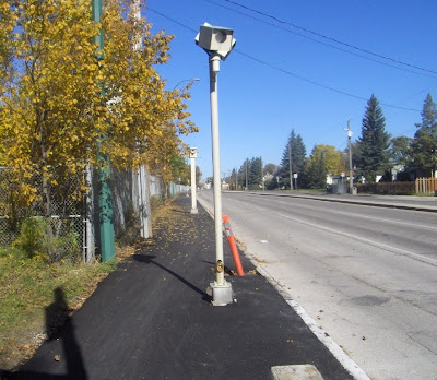
The best part is where the path narrows to only 2.4 m, 1/3 of which is rendered useless by red light camera posts.

It wouldn't be hard to clip a handlebar against that post, especially at night.

An acquaintance of this blog's phoned active transportation coordinator Kevin Nixon and asked him about this. Kevin had no idea that this was the case. He knew that the path got quite narrow at this spot because, apparently, the St.Boniface Golf Course refused to part with any of it's land, but he had no idea that it was impaled by red light camera posts.

One might think that this is potentially dangerous. That perhaps somebody working on the project might stop and say "wait a second ... is this right? Maybe we should check into this." Or one might suppose that Kevin Nixon himself might tour the various projects just to make sure that everything makes sense in actuality and not just on paper.

It would be easy enough to fix: they could divert some money from the "traffic calming" measures on Grosvenor that nobody wants (even cyclists) and use that cash to relocate the traffic signal posts to the back edge of the path where they would be less in the way. As for the red light camera, the thing takes less than one photograph a day. It's probably a money-loser. Why is it even there?

Anyhow, Kevin said that he would look into it. We'll see about that. I hope he doesn't, because I'm a bit of a trill-seeker, and swerving around posts on a narrow pathway adds that extra element of danger that I crave when I cycle to work.

 
/* Google Tracker Code