Showing posts with label transportation. Show all posts

Sunday, 8 September 2013

Waverley West bike paths already cracking.


Last weekend I did some suburban exploration on my bicycle. Among the things I discovered was an elaborate garden on or near a hydro corridor, complete with garden shed, shag carpeting, mysterious 50 gallon drums and other various containers laying about. The whole operation stretches close to 200 yards from one end to the other.

what's in the shed?
This was not far from Waverley West, Winnipeg's largest new subdivision, so I decided to toodle about the Bridgwater area of Waverley West to see what was going on.

I was excited to see Bridgwater (Yes, I'm spelling it correctly. There is no 'e'. That was the guy's name. Deal with it.) because we are being told it is going to be a dynamic "new-urbanist" suburb with a town center that promises to reinvent the "neo-traditional architecture of early-20th-century". Already this area is being compared to the walkable Corydon and Osborne Village neighbourhoods. -fp-

Sure, it doesn't look like much right now ...

Bridgwater Town Centre

... but just close your eyes and envision the multi-use buildings lining the sidewalks with patios, clock towers, fountains, and people bustling about. This is going to be no ordinary suburb, I'm telling you!

Roundabout!
Part of this new ethos of suburban sprawl is a focus on active transportation. As we mentioned in a recent post, Bridgwater will incorporate a network of trails that will allow people to get around while mostly staying off the roads. I fully support this concept in principle.

Nice path to nowhere

As we also mentioned previously, as the network expands so too will the cost of maintaining these trails.

Especially if they're built like this ...
It's only an asphalt wound.
Yes, that's right. These brand news paths started cracking virtually the moment the steam rollers left the scene.

The path above is so new that it's not even shown on the Public Works Department AT plan as a "proposed" or "future" route. It doesn't even go anywhere, because the path that it will eventually connect with, this being the "future" path along Bishop Grandin and Kenaston, is nowhere near being constructed.

See I told you it was a path to nowhere.
So this brand new path that is already cracking will have to weather at least one more freezing winter and spring thaw before it even connects to something and becomes useful.

 The crack shown above is certainly not a one-off. There are many more like it, though this one is probably one of the worst on this stretch. But why is this cracking so soon? Did the company that poured the concrete in the new Investors Group Field win the bid to construct these paths? I know that some paths have problems with tree roots causing cracks, but there is not a tree anywhere near this path. It was constructed on newly graded treeless terrain.

Another question: why did these paths even get built at this time when they're not on the Public Works AT plan and don't go anywhere?

Another question: why are we spending $330,000 on an active transportation master plan, when the city goes completely off the map and doesn't follow the plan we already have in place? The thing about a plan is it doesn't work as intended if you use it to prop up the uneven back left leg of your desk.

Perhaps this Master Plan will be followed and will result in an orderly and sensible trail building strategy. That would be great, but there is only so much a plan can do. One thing it cannot do is ensure a path is properly constructed so that it doesn't crack before anybody sets foot on it.

Sunday, 21 July 2013

Zipper Merge

So I was driving recently on the freeway in Saskatoon and ... oh wait ... maybe I should explain for those of you who have never driven in a city besides Winnipeg: a "freeway" is a road with no stoplights where you can drive at highway speeds. Saskatoon, a city one third the population of Winnipeg, has one. It's called Circle Drive.

As I was saying ... I was driving on Circle Drive in Saskatoon when I approached a construction project to extend the freeway to the west. That's when I saw it: a sign that said "ZIPPER MERGE AHEAD".

source: http://ckom.com/story/circle-drive-millar-back-normal/110318
The concept is simple: drivers are to stay in their lane until the point at which one of them ends, and then they are to take turn merging -- one from the left, one from the right -- like a zipper.

I quite like it.

It's a nice alternative to the situation that we normally encounter here in Winnipeg. That is, the majority of drivers all pile into the single lane that is continuing, causing a huge backup in traffic. Then a minority of drivers zip ahead and cut in at the front of the line or somewhere close to it.

There are a couple of problems with this, one being that it creates an unnecessarily long traffic queue, another being that it causes animosity among drivers. The drivers who get in line right at the start of the queue and wait patiently as the line trudges along resent the selfish nimrods who zip past them in the empty lane and cut in at the front.

But why should you get in line half a mile before the construction starts when there is a perfectly good lane that can legally take you right up to the merge zone? That isn't rational.

I've been on both sides. Sometimes I get in line, and when I do I get annoyed at those who don't. Depending on what kind of mood I'm in that day, I may even do my best to keep them from merging in front of me. Sometimes, if I'm in an unusually pissy mood, or if the guy trying to merge is driving a pickup truck with a license plate that says "GORJUS" and is wearing a ball cap backwards (I have seen this), I'll even tease them by leaving space for him to merge and then closing up to the car in front of me at the last second, and then I'll go extra slow to give the guy behind me a chance to close up behind me too.

That's how I roll.

However, sometimes I'm the douche bag who zips up the empty lane, although in my head I say to myself "Oops, is this lane closing off? Gosh, I hadn't noticed. I guess I ought to merge over here at some point." -- as if I can telepathically communicate to the drivers waiting in the queue that I didn't mean to drive up the empty lane, it's just that I didn't notice the construction signs. Silly me.

However, I won't drive right to the front of the line because that would be rude, and it would negate the little excuse that I made for myself that I only inadvertently failed to get in line.

This is all normal behaviour, right? Good. Just checking.

Sometimes those who set up the construction sites make it worse than it needs to be. For example, the signage for the construction on the Pembina overpass on the south Perimeter Highway in Winnipeg begins more than 2 kilometers in advance of the lane closure, with signs that warn you that there is a lane closure ahead and the speed limit is reducing to 70 km/h. As a result, most drivers pull over into the right hand lane and slow down to 70 km/h on the highway so far in advance of the construction that you can't even see where the construction begins.

*****

In writing this blog post, I found out that the zipper merge is a new thing for Saskatoon. They only started to experiment with it in May, because, as one person put it, "People have been so bad historically in this city anyway on road construction and merging that anything might improve it".

Saskatoon borrowed the idea from the state of Minnesota, a pioneer in the zipper merge revolution, and so far they have found that it works quite well. My own experience with it was pretty good. I mean, about as good as merging at a road construction site can be. It's not comparable to, say, a full-body hot oil massage, but you know ... it wasn't painful.

The Minnesota Department of Transportation says that the zipper merge "has proven to help traffic flow by decreasing queue lengths as much as 35 percent" and "reduced lane-changing conflicts and sudden-stop crashes."

However, even in Minnesota not everyone is an advocate. One blogger: "I get how the zipper merge is supposed to work, the problem is the people who don’t. ... The zipper merge is going to be this century’s conversion to the metric system in the ’70s. Great idea, made perfect sense, and was dead on arrival."

Much like a roundabout, I don't know how you could fail to understand how it works. Having never experienced such a thing before, I found it exceedingly easy to understand. Mind you, I have underestimated the stupidity of other drivers before.

Even if some people don't catch on to the concept of a zipper, I think it's worth trying out here in Winnipeg because it eliminates the dilemma of deciding between two bad options: burn 5 minutes of your life in a line of cars, or be rude and selfish by cruising to the front of the queue.

Taking turns is something we're taught to do as little kids. As adults driving cars it shouldn't be that hard.

Tuesday, 20 November 2012

Around This Town: Slurpees, Surefoot, Speed limits and Stumbling

This is big news. HUGE news. 7-11 is now at the airport!!!!

See? Right there. 7-Eleven number 25.

I haven't seen it and I don't think it's actually in the airport terminal, but nevertheless it's conveniently located such that when you come back to Winnipeg from some inferior place that does not love Slurpees as much as us, the first thing you can do is buy a Slurpee!

Also, because of the strategic location, 7-11 has introduced a new 100 ml Super Small Gulp that you can take on the airplane.

Okay, I just made that last part up.

*****

This is big news. HUGE news. Especially if you're a frail old lady. That's right: www.surefoot.org is up and running again!

A full two weeks into November and a week after our first big snowfall of the year, the website had absolutely nothing to report.

Now, thanks to a team of IT professionals working around the clock to restore surefoot functionality, the online sidewalk safety tool now informs you that you should take precautions when using sidewalks.

This is tremendously important for those older folks and people with disabilities who would otherwise have danced down the sidewalk wearing rollerblades.

Now that surefoot.org is back up and running, we can rest easy knowing that Councillor Harvey Smith will not fall down this winter.

(Really, I like Harvey. He cares about the city and he's a very engaged person. I sent him an email one evening and he called me within half an hour and we had a good long chat. Usually the most you get is a one word reply.)

*****

This is big news! Speed limits are being reviewed, and this time we're not talking about making them lower, but actually increasing some of the ridiculously low limits that you see around town. I give a tip of the hat to Winnipeg Girl for pointing out the CJOB web site with the details.
That's a great summary by CJOB, with Google maps and a description of the proposed increase.

I've written about this before, but increasing speed limits has been proposed in the past only to be shot down by a city hall committee with little consideration. Hopefully the Manitoba Traffic Board's consultative approach this time will have more success.

You know people will come out and oppose this, saying things like "a person has a 30% better chance of surviving an accident with a car going 50 km/h than 60 km/h" and so on. That's a false argument though, because if you take that to it's logical conclusion all speed limits should be set to 0 km/h.

In reality, the safest speed to drive is the "natural" speed of the road ... the speed that people tend to drive. The "85th percentile" that traffic experts recommend speed limits be set at. If you set speed limits too low then there is more lane changing and shuffling of traffic, and more people will take short cuts down side roads endangering kids.

I'm usually not a big fan of obscure provincial boards, but GO Manitoba Traffic Board!

*****

In blog news, the blog Stumbling (A)Bordeaux is gone. Like a puff of smoke, it has vanished into the ether, posts and all. Patrick Oystryk went out with a strong final post "Winnipeg: a Recycled City" -- a sobre evaluation of Winnipeg's shortcomings from somebody who just spent a few years living in Europe. He has hinted at starting up something new now that's he's returned to the 'Peg, so stay tuned.

It's a personal decision, whether to delete it all when you hang up the blogging gloves, or keep things on-line for posterity. I selfishly prefer the latter, because there was a lot of good content that has disappeared from the likes of Patrick, David Watson of Waverly West and Beyond, Walk Krawec of One Man Committee, and others.

Speaking of One Man Committee, it popped up on my blog roll again today. There is only one post with nothing in it, and the author is now Kindra Cahya. What's up with that?

*****

Lastly, this Friday is the 16th annual LITE (local investment toward employment) Wild Blueberry Pancake Breakfast at the Indian and Métis Friendship Centre. 

I will be there flipping pancakes or washing dishes or, given the time of day, slumped in a chair drinking coffee. Maybe see you there!

Monday, 10 September 2012

Speed limit proposal based on bad statistics.

Winnipeg City Council is discussing lowering speed limits to 40 km/h in residential areas. The justification for this includes a study conducted in Edmonton that appears to show a great benefit to lowering the speed limit. It's even baked right in to the proposal before council.

 The proposal includes the following:

AND WHEREAS the City of Edmonton recently reduced speed limits to 40 km/h in several residential neighbourhoods with a 25% drop in severe collisions;

THEREFORE BE IT RESOLVED THAT Council ask the Winnipeg Public Service to consider lowering the residential speed limit in Winnipeg to 40 km/h
Here's the problem: THE RESULTS ARE INSIGNIFICANT.

From the study:
However, these reductions were not significant, as the 95% confidence interval included zero, implying no change or no effect. Generally, when a confidence interval is very wide like this one, it is an indication of an inadequate sample size (i.e. short “After” period) and implies poor precision. Consequently, the results of the collision analysis were inconclusive and additional research will be required to substantiate the impact of the pilot project on the number and frequency of collisions.
(emphasis mine)

That's a big problem with research related to public policy. Give a politician a study that says "implying reductions in predicted collision counts of 25% with a 95% confidence interval of -81%, 77%" and the politician will read "blah blah blah 25% reduction in collisions! blah blah blah."

I read "95% confidence interval of -81%, 77%" and see "these results are as useful as a tampon dispenser in my garage".


Some may also point out that the study showed a statistically significant decrease in operating speed in the study areas with the 40 km/h speed limit, but the decrease only averaged 3.95 km/h. Assisting with the decrease were the following factors:
i) a pre- and postcommunication plan;
ii) installation of new speed limit signage and setting up speed display boards, dynamic messaging signs and school dollies;
iii) implementing community speed programs (i.e. Speed Watch, Neighbourhood Pace Cars and Safe Speed Community vans) and
iv) using covert photo-radar trucks.
It was the result of a full-out blitz to increase awareness and reduce speeds, with a modest result of 4 km/h.


Look, I don't want kids to get run over by cars any more than you do, but this isn't the answer. Most people already drive a reasonable speed in residential areas. This isn't going to change that. What this will do is lower speed limits on collector streets where 50 km/h is a reasonable speed, but are deemed "residential", providing more opportunity for the police to set up radar traps to ticket drivers who are driving in a responsible manner.

What we need in this city is a common-sense approach to setting speed limits. It is insane that Kenaston Blvd has the same speed limit as Valour Rd. Set speed limits at levels that reasonable according to industry standards (ie. 85% percentile) and adjust as necessary for special cases like school zones. Let's not create misguided legislation based on inconclusive data and misinterpreted studies. That never turns out well.


Sunday, 29 July 2012

Moving the CP rail yards

The Winnipeg Free Press has taken the dormant issue of moving the Canadian Pacific rail yards out of central Winnipeg and yanked it into the spot light with their special series Off The Rails. I'll concede that it's worth talking about, but why now exactly? Why not? It's a time of change for Canadian Pacific, and that may mean that issues like this will get a fresh look by the new CP honcho, Hunter Harrison.

For those not familiar with Harrison, he was CEO of CN Rail when the CN Intermodal yards on Taylor Ave in Winnipeg were moved to St.Boniface, making way for what is now IKEA and the Seasons Of Tuxedo shopping centre.* He went on to push CN to ever greater operational efficiencies and share prices. After a recent shareholder revolt, he is now CEO of CP and thus in a position to move the CP yards if he deems it necessary. He is already moving forward with plans to consolidate other rail yard operations. The Etobicoke and Agincourt yards in Ontario are apparently being mothballed, and consolidations are coming to the Montreal area I am told.

I still think it's unlikely the Winnipeg CP yards would be moved from where they are now. It would be a massive cost, and therefore would require massive operational efficiencies to make it worthwhile. Harrison is committed to investing in rail infrastructure, but something of this magnitude would probably not be in the cards when there are so many other areas were capital investment is needed. Unless ... it was bolstered by massive public subsidies.

I think all the talk of it being a remedy for our inner-city problems of crime, poverty and homelessness is greatly overblown. Lloyd Axworthy calls the railyards "a psychological barrier between rich and poor". Which side is rich and which one is poor I haven't figured out yet. Both are low income areas plagued with high crime rates. Removing the "barrier" is supposed to allow the socioeconomic well being of the West-End, such as it is, to spread to the North-End. Just as likely is that their respective criminal elements will combine and multiply into a giant crime bomb with it's epicentre being the former rail yards.

I am being a little bit facetious, for those of you who don't know me. I do think some good can come of it, but we need to keep our expectations reasonable. If you plunk a community between two disadvantaged communities, that new community is likely to also be disadvantaged.

*****

Let's assume the rail yards are moving so we can get to the fun stuff. What would we do with all the space?

I would be hard-pressed to draw up a better plan than what Cold Cold Ground cooked up over here, though the Weston area is excluded from that plan. I think what I'll do instead is some more general thinking about the area...


Housing is probably the first thought for most people. Housing and green space. We do have a shortage of affordable housing in this city, but the draw back of this area is that the housing would be sandwiched between the light industrial areas along Logan and Dufferin. However, there is potential to convert some of those buildings into warehouse apartments to better integrate the new and old residential areas.

You have to realize, though, that the appeal of inner-city housing is limited. Especially when it's not in a trendy area like Wolseley. I don't think you can fill the vast area of the CP yards with housing and expect it to be successful, therefore we have to do some creative thinking to make the best use of the area.

Here we go ...

Zone 1: Red Light District
Some of the areas adjacent to the tracks are plagued with prostitution and all the associated troubles. Every so often there is talk of a red light district as a potential solution, but who on earth wants a red light district in their neighbourhood? That's why this area is ideal -- it has no neighbours. At least not residential ones. It's an ideal opportunity to A) draw prostitution away from existing residential neighbourhoods, and B) draw in tourists. Some archaic laws about operating a bawdy house may need to be changed. If you were to make cannabis bars legal for this designated area that would really draw in the tourists. Move over CMHR, there's a new game in town. Throw in a few casinos and you've got a thriving tax-dollar generating mecca in a small area that would be easy to police.

Zone 2: Golf Course
This area is more than large enough to support a full-length championship golf course. This would integrate very nicely with the red light district across the street. Hotels will start springing up in the area, and even I might go there once in a while. (For the golf, not for the hookers .... just to clarify.)

I know that a few months ago I was advocating getting rid of golf courses, but remember: the problem is not too many courses but too many small, crappy, money-losing courses. A medium to high end public championship course would add variety to the golf market here. Meanwhile, some of the existing courses like the Canoe Club are in much more desirable residential areas and could be converted for that purpose.

Zone 3: Residential
Yawn.

I couldn't make everything fun. But what kind of residential and how do you do it? Do you just sell the land to Qualico and let them loose? Should we turn it into a big Manitoba Housing development? We need affordable housing, but we don't want to create "projects".

I like this enclave of colourful little single-story townhouses that was build near the Old Ex grounds just north of the tracks. It's called Flora Place, and was build in 2007 by a government bureaucracy called the Winnipeg Housing Rehabilitation Corporation.


It was heavily subsidized, to the tune of $125,000 per unit, but still appears very well maintained. you get the impression driving by that the occupants take pride in their houses.

Closer to downtown, east of Salter for instance, a higher-density of development might be appropriate. Apartments or perhaps a brownstone-style development...


Throw in a end-to-end strip of green space (not too much) and an AT corridor. That's about as far as I can go with this.The details about deciding which street goes where can come later, but that's my general vision. You can see other people's ideas at the Winnipeg Free Press Café Tuesday evening at 6:00, where a "design summit" will be held.


*He was Chief Operating Officer and Executive Vice President when the decision to move the yards was made, taking the CEO position shortly thereafter and prior to the execution of the plan.

Monday, 11 June 2012

Simplicity in parking

While I was loitering on the streets of Montreal recently, I snapped a photo of their parking system downtown. I was struck by how clear and how simple it is. In downtown Montreal the parking spaces are marked on the roads in lines and each pair of spaces has a marker like this:


Pay at the station and go. These are the times that you have to pay. Everything is easy to read ... even the French. The actual meters that dispense the tickets are equally simple. It's all explained here on an equally clear and simple website.

Winnipeg's parking meters, by comparison, are a dog's breakfast:


 There's a lot going on there. Let's take an extreme close up of the main part:


What does that say in the blue? Minimum Change? Minimum Charge? It's Mon to Sat but it's enforced daily? What is all that little typing at the bottom of the dark yellow section?

I've been told that we get two free hours of parking on Saturday, but I don't know how the hell I would tell that from this label. If somebody has poor eye sight or a bad hangover they wouldn't even be able to read the days and times.

To make matters worse, the rate is different depending on where you are because certain meters are operated by different authorities like Forks-North Portage or Health Sciences Centre, and then there are the proposed "high demand zones" with special rates. See the 34 page presentation for more information, including the "parking triangle" that tells us that we cannot have "convenience", "availability" and "price".

Much like Montreal, Winnipeg's parking authority has a web site. That's where the similarity ends. Winnipeg's web site features 39 paragraphs, 860 words, and zero diagrams. It contains useful information if you want to park downtown, such as:
Payment for the full 4 hours of parking is required if you park at a 2-hour paystation and use payment methods other than coins or a credit card (ed. note: WTF?)
If you like to leave your heater on defrost, fan on high, and start your car from inside fifteen minutes before your appointment is over, your receipt will end up on the floor.
Always check for signs indicating parking restrictions before you pay for on-street parking. If more than one sign is posted, look at the signs starting at the highest sign and work your way down. (Translation: if our meters don't confuse the fuck out of you, our signs will.)
Fortunately the web site also links to a video called "How Pay Stations Work". Unfortunately, it shows up as nothing more than a black screen using Firefox.

Our pay stations are so complicated that they have their own language.

If you're planning on visiting Winnipeg, my advice to you is:
- make sure your contact lens prescription is up to date.
- leave plenty of time
- when in doubt, you had better put in money. But just remember:

"In rare cases, the paystation may accept payment when it should not."

Tuesday, 29 May 2012

Confusion Corner redesigned and unconfused

The infamous Confusion Corner -- an intersection that makes you cut through a parking lot or down back lanes to get to where you want to go. The thriving and walkable Osborne Village comes to an abrupt end at this tangle of traffic, and the integration of the Rapid Transit station into the fabric of the community is all but impossible as long as it remains in it's current configuration.

In February the blogger at The Cold Cold Ground devised a new plan for Osborne's confusion corner; essentially a big round-about. Now you know I love my roundabouts, however there will still be a great deal of traffic flowing around this bout, and therefore it still presents a problem.

In the comments of ekim's post, I wrote

Excellent! I applaud your initiative in taking a crack at improving that area. It would be great if a number of people sketched out their designs, and had a brain-storming to work through the best aspects. And.. made city hall listen some how.
Well I thought I should put my crayons where my mouth is (yum) and take a crack at redesigning the intersection and unleashing the ultrawalkable-transit-oriented-urbanity of the Village.

Here's the nut of the problem: you have a great deal of traffic passing through the area, cutting off Osborne Village from anything south including the Rapid Transit station. Much, if not most of that traffic is going straight across from Donald to Pembina, or Pembina to Donald. Anyone wanting to get to or from the rapid transit station has to cross this traffic.


My solution is relatively simple: get rid of the traffic.

The "how" may seem far fetched to you, but keep in mind that cities do this all the time. Calgary is doing it as we speak. That is: build a tunnel. Get that Donald to Pembina traffic underground so that it can bypass the intersection without causing traffic jams, and creating an inhospitable environment for pedestrians. The details of getting it underground need to be worked out, but I envision an end result like this:


I need to rework the tunnel entry points, but the gist is that the outside lanes break off to feed Osborne St. and Corydon Ave, while everything else boots happily along underground. What used to be eastbound Donald St. would become a 2-way street and rebranded Corydon Ave up until the point that the traffic from Pembina rejoins it.

All you are left with at the former crazy corner is an ordinary four-way intersection: the corner of Corydon and Osborne. How iconic would that be? What used to be a big web of crisscrossing traffic could become the most in-demand restaurant and patio spot in the city. Two of the best urban neighbourhoods in Winnipeg would be linked through this intersection. The only traffic passing through would be traffic that wants to go down Corydon or Osborne. The impatient suburbanites racing home to Waverly West from downtown are nowhere to be seen.

Aside from the part about tunneling underground, this wouldn't be that hard to do. All of the roads are essentially in the same place. Donald is re-purposed as Corydon, and McMillan Ave is basically the same, only less fucked up. No buildings would have to be torn down except perhaps to allow for the off ramps where Pembina and Donald are fed underground. Meanwhile the wasteland south of McMillan would be much more accessible, opening up the possibility of true transit-oriented development around the RT depot.

Yes, this would cost money, but just this past month City Hall decided to go off-schedule and spend $300 million on new roads in parts of the city where people don't even live. If the brains at the City of Winnipeg were inclined to build a tunnel, they could build a tunnel. They just might have to delay the next phase of freeways in canola fields.

... the corner of Corydon and Osborne...imagine it!

And to finish off this blog post, here is a photo that I took in New York of what I think is the Holland Tunnel:


Friday, 27 April 2012

What to do with the Master Plan?

About the only surprise is how soon it happened, though the fact that it happened was all but inevitable. On Wednesday, Winnipeg City Council rendered yet another planning document obsolete by approving a proposal to disregard the recommendations of the Transportation Master Plan and fast track road expansions on the periphery of the city:

Amid hubbub, $300 million in freeways approved

Said Dan Vandal, who is emerging as one of the few voices of reason on Main Street:

"I think it sends the wrong message to administration and to the province, who I'm sure paid for half of the master plan. The fact that we can make these $300 million in changes without any administrative comment on whether they're worthwhile is bizarre."
Yes, well bizarre is the name of the game at City Hall.

This change, while fast tracking new roads, no doubt also delays the rapid transit portion of the master plan until some time after the Great Apocalypse. In retrospect, I probably shouldn't have wasted my time writing about it or going to the open house, although they do have good cookies at these open houses.

Nevertheless, we spent $1.25 million on this document, so we should try to make some use of it.

My first thought was to use it to line bird cages, but nobody keeps birds anymore. (Why is that? They're small and colourful. What more could you want in a pet?) 

My second thought was that we could use the pages of the Transportation Master Plan to teach kids origami. They could start by doing very simple projects like paper airplanes. This is ideal because it's tangentially related to transportation.

But then it occurred to me that the plan is in PDF format. It is very difficult to make a paper airplane out of a PDF file. I tried once and it was incredibly frustrating. In the end, perhaps the best use we can make of this document, as flawed as it is, is to lock it away in a time vault to be opened in 20 years so that the next generation of community leaders can compare what was supposed to be with what actually happened, and hopefully get cracking on that second leg of rapid transit to the U of M.

Monday, 2 January 2012

New Winnipeg Forum / Photo Radar Photo Op

Get in the Zoom

A new Winnipeg discussion forum has sprung up, not to be confused with the New Winnipeg discussion forum. This new forum called Winnipeg Zoom was started by former New Winnipegger Munchkinguy (Gabriel Hurley) to fill the void left by the defunct NW forum.

How big that void is remains to be seen. There is lots of competition in the internet time-wasting market, not the least of which is the ever-growing and ADD-enhancing Twitter. In fact, as I typed that 3 more tweets hit my feed, and now I have to go check it again. Hang on a sec ...

.. Okay I'm back. Oh that Rav Gill is such a card. I wish he was mayor. Where was I .. Oh right: do check out Winnipeg Zoom. It is brand new and still building momentum (or "mo" if you're as cool as I am), but hopefully it gets to that critical mass needed to sustain interesting and dynamic discussions like New Winnipeg once did. I do like the layout, I'll say that.

Get in the photo

Wise-Up Winnipeg is organizing a photo op Saturday morning at the sight of the controversial Grant and Nathaniel speed trap where they say inaccurate radar tickets are being issued. That's what they say. I say it's just a hot spot for minivan drag races.

Anyhow, if you want to support the cause, contact Todd Dube at mediascene@mts.net
to let him know you'll be there and then show up 11:00 am Saturday to get your free sign that looks something like this:

That sign doesn't do much for me but I'll show up if you can give me a sign that looks something like this:

Sunday, 18 December 2011

The speed limit is too low. I have proof.

If you follow local Winnipeg news, you probably heard about the kerfuffle over a photo radar speed trap at Grant Ave. and Nathaniel St. where the Canadian Taxpayers Federation and anti-speed trap advocates Wise-Up Winnipeg are urging people not to pay their tickets because they believe the speeds aren't being measured properly.

Earlier in the year, Wise-Up Winnipeg also questioned whether the speed limit was properly posted on this stretch of road.

Here's the thing: even if the speed limit signage is posted correctly, and even if the radars are calibrated properly, these tickets should never have been issued. Why? Because the speed limit itself is incorrect.

This is not just my opinion. It is fact. I'll explain: In 2003 a report was submitted by the Winnipeg Public Works Department titled "SPEED LIMIT ON GRANT AVENUE AND ON KENASTON BOULEVARD". The report was conducted by traffic analysts and signed by J.A.Thomson, Director of Public Works. It has since been removed from the City of Winnipeg web site (at least I can't find it) but I happen to have a copy.

It's conclusion:

"The measured 85th percentile speeds on Grant Avenue between Stafford Street and Kenaston Boulevard and on Kenaston Boulevard between Grant Avenue and Academy Road range between 61 and 68 km/h. The collision rates ... are comparable to the city-wide average of 3.3 on regional streets with similar characteristics. Based on this information and on the widely accepted practice for setting speed limits using the 85th percentile speed, it is reasonable to set 60 km/hr speed limits on Grant Avenue between Stafford Street and Kenaston Boulevard and on Kenaston Boulevard between Grant Avenue and Academy Road. Furthermore, it is expected that making these changes ... will (i) result in more efficient transportation routes along these streets, (ii) reduce the incidence of short-cutting traffic on adjacent residential streets, and (iii) provide motorists travelling along these routes with a more consistent driving environment in terms of uniformity in speed limits."
When this study was brought before council it was rejected for unspecified reasons:
"The Standing Policy Committee on Public Works did not concur in the administrative recommendation and therefore did not increase the speed limit.
Further, the Standing Policy Committee on Public Works requested that in the future, consideration of speed limits be referred initially to the Ward Councillor and if necessary to the respective Community Committee." (soucre: Minutes - Standing Policy Committee on Public Works - January 13, 2003)
The traffic analysts collected all this data, did all that analysis, and council just tossed it into the garbage can without any apparent consideration. Even if the policy is good the optics are bad, therefore the elected councillors won't even touch it. Get the Community Committee to agree and maybe we'll consider it ... as if that will ever happen. That's leadership for you.

There is a permanent red light camera installed on Kenaston Boulevard between Grant Avenue and Academy Road at Corydon Ave., and this Nathaniel St. mobile speed trap is on Grant Avenue between Stafford Street and Kenaston Boulevard. In both cases tickets are being issued to drivers that are driving a safe speed according to traffic industry standards. It is immoral and objectionable and counter-productive to issue speeding tickets to people in areas where you KNOW the speed limits are too low.

The reason I found this study in the first place is because a few years ago I was nailed with a photo radar ticket on Kenaston Blvd. I challenged it in court. I presented this study as evidence to show that the speed I was driving was safe according to accepted standards and argued that enforcing this ticket violated the intent of the law, which ultimately is to make streets safer. In fact, enforcing an artificially low speed limit can make streets more dangerous because it causes speed differentials to increase (less consistency in the speeds people drive) which leads to increased accident rates.

Unfortunately the judge I got was completely incapable of comprehending this argument. "But .... you were going over the speed limit."

GAAAAAA! This is why you're almost at retirement and still stuck working traffic court! (I didn't say that out loud.)

Perhaps if I had appealed I would have got a judge with a capacity for independent thought and abstract concepts, but appealing takes time and money and I wasn't up for the challenge at the time. However, if one of you have recently been dinged with a ticket in one of these areas, I will gladly send you this study and I will give you my full support and encouragement as you attempt to fight your ticket.

Wednesday, 2 November 2011

Transportation Master Plan. (How exciting!)

According to Blade Runner, filmed in 1982, we will have colonies on other planets and androids so perfect as to be "more human than human" by the year 2019 -- only 8 years from now. Think about it: that's when Hugh McFadyen was planning on balancing the Manitoba budget. In fact, in the movie the 'Nexus 6' model of replicant has already reached the end of its 4 year life span, meaning in only 4 years we will be building these 6th generation bots that are so advanced that you can have sex with them and make them breakfast without even knowing they aren't human.

People, I think, have a tendency to believe things will happen faster than they really will. Sometimes things do progress quickly ... for example: in 1918 we were flying biplanes in WWI, and less than 30 years later we had jet airplanes and nuclear weapons. In other cases the pace of progress disappoints. Which brings me to the point of this post ...

The City of Winnipeg has unveiled their $1.25 million Transportation Master Plan. There are two major components to the plan: a $2.7 billion rapid transit initiative, and $2.1 billion in road improvements. Sorry: "improvements". All of which is to come to fruition (did I really just use that word?) in a mere 20 years. (The active transportation component is mostly window dressing and can be discussed separately some other time.)

ROADS

To me, road improvements would involve making existing roads better. Maybe I misunderstand the term, because the focus of the "improvements" in the Master Plan mostly involve adding miles of new roads on the periphery of the city, sucking more infrastructure money away from the populated areas of town. I personally would call this "facilitating sprawl", but what do I know?

There are plans to widen Kenaston and St.Mary's, which will help. Otherwise, the focus is on building a ring road network inside the perimeter highway and around CentrePort. This plan is a component of the overall OurWinnipeg plan. In the Our Winnipeg plan, there is a map that identifies key "Regional Mixed Use Centres" and "Major Redevelopment Sites". For giggles, I decided to plot these destinations on the map of road improvements from the Transportation Master Plan -- green circles for Mixed Use Centres and yellow rectangles for Redevelopment Sites:


Virtually all of the road improvements on the map lie outside of the key urban areas identified by the City's own visionary document. We are building a web of roads around the city while the roads in the city that people use everyday get more cluttered and dangerous. Supposing we could actually get our hands on $2.1 billion for road improvements, I propose fixing some of the poor planning of the past, rather than just saying "oh well, what's done is done .. let's build more roads!"

I'll give you an example: Fermor @ Lagimodiere is a busy intersection and a dangerous one, ranking #2 in the city with $5.9 million in bodily injuries in an eight year span. . Instead of spending $80 million building an extension of Bishop Grandin to Fermor, why not spend the money fixing Fermor @ Lag? There is plenty of room for an overpass, ramps, merge lanes or whatever. But no. Instead we will build a redundant road through a field, resulting in 3 dangerous and annoying intersections where before there were only 2.

I looked for answers at the Master Plan Open House today . The guy I was talking to explained that the purpose of the Bishop Grandin extension was to provide access to the Sage Creek and Southlands neighbourhoods, which makes no sense at all for reasons I'll explain in the comments to save room up here. I had it out with this guy over all kinds of road-related things, but generally related to poor planning and creating a sprawling network of roads. He scoffed at the idea that developers should or would pay for proper infrastructure. My response: if there is demand for another 10,000 houses or a sprawling retail development, the developers will pay what it takes. There is no need to encourage faster sprawl by cutting corners on infrastructure, and by building new roads in the middle of farm land.


RAPID TRANSIT

A lot can happen in 20 years, but apparently not rapid transit in Winnipeg. I don't even know when the rapid transit planning started, but in the last decade all we've accomplished is a partially completely 3.2 km piece of pavement for a yet-to-be-determined mode of transportation. I was not encouraged by the sign board at the open house that said the SW Rapid Transit Corridor was expected to be completed "Before 2031". What, is Sam planning on running for mayor another 5 times?

I certainly support its development, and I have no initial complaints about the proposed routes in the plan -- except the maybe it will maybe it won't .... But it will ... jog in the SW transit corridor away from Pembina highway into the controversial proposed new development. But let's be realistic: we just came off a decade of economic growth, budget surpluses, and increasing transfer payments, and we got nothing done. We are now in a period of slow economic growth and massive budget deficits. How will we get money for this? If comes down to a choice between rapid transit and new roads, I fear new roads will win out. After all, we at least know what kind of roads we're going to build, and there's less resistance to building them given that most are in the middle of nowhere.

The bottom line is that if we really want to make rapid transit happen, we need determined and decisive leadership, both within the City of Winnipeg and the Province. Place your bets now. While we can put together glossy $1.25 million transportation plans, the sad reality is that I'm more likely to have my Nexus 6 sex bot order filled before we have anything close to efficient transportation infrastructure in this town.

Wednesday, 26 January 2011

CTV on Walmart / Russ Wyatt on Ski Doos

Well, let the knee-jerking begin. Somebody died, therefore we must change laws regardless of whether it makes sense or not.

Look, I'm not heartless. I actually have a bigger heart than most people, as I upgraded several years ago to a water buffalo heart on a visit to a Africa thinking it would make me better at golf. I'm not sure what this heart thing has to do with compassion, but I'm pretty sure I have that too. I also have logic. It's important to have both, otherwise you end up saying things like Russ Wyatt.

Wyatt today announced several things:
1) he wants to ban snomobiles in areas within city limits where they are currently allowed.
2) he wants to be able to seize the snomobiles if they are caught driving in said areas.
3) he wants to increase the minimum driving age to 16.

Let's discuss:

1) All we're doing is creating more law breakers for no apparent reason. People are going to do it anyhow, because there is really no reason not to except that, um, some guy who was driving in an area where it was prohibited hit somebody who was walking in the dark in the middle of a field near a Hydro right of way. Ya, that makes perfect sense. No logical fallacy there.
2) If you think it's hard to catch a car thief, try catching a snomobile driver that's afraid of having his $16,000 MX-Z 800R confiscated. Good luck. Maybe you can deploy the police helicopter to track snomobiles in a field instead of car thiefs in the middle of the city.
3) Makes sense, right? Older ... more responsible ... But is this really going to help? Driving a snomobile for 10 years before I got my drivers license helped make me a better driver. In fact, I would almost recommend that we make it mandatory.

Russ continues his silliness with this quote:

"10, 20, 30 years ago we didn't have snowmobiles that can go 160 miles per hour"

So, the reason for changing things now is because snomobiles can go faster? The olde power toboggans of yore didn't go fast enough to run somebody over? The old Jag 340 I used to drive could go 60 miles per hour, and that was probably one of the slowest snowmobiles in town. Russ is just grasping at straws. There is probably lots of straw in that field where Ken Stammers got run over. He can go there ... as long as he wears something reflective.

***

Another thing that I saw on CTV this evening was that Walmat was going to build "supercentres". They're like centres, only they're super!

This was one of the lead stories, and I thought to myself: why is this a lead story? Actually, why is this a story? Do other stores get news coverage when they expand their product line? The advertising execs at Walmart are no dummies. How do we let people know we're expanding our grocery area? Buy TV advertising? Buy billboard space? No .. just send an email to CTV. They'll broadcast it to the province for free.

I am left wondering if there was some sort of real local news that I missed. Wasn't there some kind of meeting at city hall? There must have been, because they mentioned in passing that the councillors voted to approve the 58 new cops. Is that all they did? Anything else I should know about?

I would dare to say that the things our elected officials decided today is a little more important than the fact that Walmart will start selling meat in 4 months. Mind you, after looking at the "most views" list on the Free Press web site, I might be mistaken there.

Tuesday, 25 January 2011

Another roundabout!

Even though the only way you'll catch me in East Kildonan is if I get kidnapped or drive without my glasses on, I am very happy to learn that E.K. is getting a new Roundabout, because it means the City has not let the traffic circle debacle of last fall scare them away from building proper roundabouts.

Those of you who are new to this blog may not know this, but I have a bit of an obsession with roundabouts. I advocated for them two years ago. I rejoiced when they built one in my neighbourhood, and I'll complain about four-way stops to anybody. That is why I was slightly concerned when those little mutant "traffic calming circles" caused a shit-storm to erupt that even had the Director of Public Works basically saying on TV that people were too stupid to use them. Fortunately common sense has prevailed and a properly designed roundabout is still recognized as a efficient traffic control device.

In fact, if you elect me as mayor, I pledge to replace four-way stops with roundabouts whenever possible: everytime an intersection with a 4-way stop is due to be rebuilt, if it needs to be torn up for a major repair, or if traffic congestion demands it.

Not only that, if you elect me as mayor, I will

  • implement a one-in-one-out policy for traffic lights. Do we really need to put up another set of lights on route 90? Fine .. let's figure out how to get rid them somewhere else. We rely far too much on lazy planning.
  • actually implement traffic analyst recommendations regarding speed limits.
  • restrict new residential development on the edge of the city until somebody can convince me it's absolutely critical.
  • ensure that all new development -- residential or commercial -- is properly funded, so that we don't build neighbourhoods without schools or massive commercial developments without proper infrasturcture.
  • Get rid of red light cameras in areas where .. wait ... what? The election was last year? Damn. Never mind.

related: Graham Hnatiuk

Sunday, 12 December 2010

Five Star Regulation

This blog's hit count has been creeping up over the past couple of months. I have been informed by the Provincial Web Log Regulatory Agency that I have exceeded the number of hits that I am allowed, given current internet traffic demand conditions in Manitoba. Therefore, I am required to drive away readers by writing an excruciatingly boring post about something buried deep in the business section of the Winnipeg Free Press.

I chose City bus charter's plan to expand hits red light as my victim. On page B6
of the Saturday Free Press, we read about how our benevolent civil service is protecting us from competition and economic growth:
A little-known provincial regulator is putting the brakes on Winston Gordon's efforts to grow his bus charter business. Gordon's 10-year-old Winnipeg business, Five Star Bus Lines, operates five charter buses and has applied for seven more licences. ... "I know there is demand," Gordon said. "People are calling me all the time and they say they can't find any buses."
That's what he thinks. The provincial regulator knows better:
Iris Murrell, secretary of the Motor Transport Board, said the board has not issued any new licences or alterations of licences for at least a year. That's because it's the Motor Transport Board's understanding that, in fact, the marketplace has not grown and the larger industry dynamics probably back that up.
...
Despite the fact some may believe there is more business out there, the MTB's intelligence is to the contrary, she said.
No indication is given of who supplies their "intelligence", but we do get an indication of the level of their intelligence:
"We are here to maintain service to the general public," Murrell said. "If something is being proposed that will have a detrimental effect on that, it will not likely get a favourable consideration from the board. In the past year or so, a few existing carriers have applied to this board to add existing vehicles or expand their restricted boundaries and they have all been refused."
They are maintaining service to the public by preventing any improvement in service to the public. That sort of logic can only be fully understood by driving a railroad spike through your brain. It seems the mandate of this office is not to ensure that a minimum level of service is maintained, but to ensure that a maximum level is maintained by preventing any sort of investment that might possibly give consumers a higher quality product.

Government bureaucrats artificially capping supply not only results in poor service, but also in high prices. This is literally first year economics:
It's not just buses. The same can be said for the Taxicab Board, who's actions have not only resulted in poor service from a restricted supply of cabs supplied by an industry duopoly, but in a ridiculous market for licenses that can cost drivers upwards of $400,000 for something that ought to cost no more than a couple of hundred bucks in admin fees.

Allowing businesses to invest and expand and compete is what drives our economy. Governments should try to facilitate that, not prevent it. Many of these of regulatory boards in Manitoba far exceed their useful purpose, and should either be cut back, amalgamated, or eliminated entirely. The only reason for regulating an industry like bus charters or taxicabs is to ensure that minimum safety standards are met (though in the case of the Taxicab Board they can't even do that properly.) Somebody with some brains on Broadway should fire Murrell, gut the MTB and the Taxicab Board, and combine them into a single Transportation Safety Board with a limited and specific mandate that does not prevent entrepreneurs from investing in capital, hiring workers, and providing a better service to the public.

I told you it was a boring post. No pictures even. (Oh, I guess I do have a graph. I hope the PWLRA doesn't make me take it down!)

Thursday, 4 November 2010

Train videos

Found on YouTube ... If you like trains and old stuff, this is for you: smokeywoodstover posted this old1946 footage of a train ride from Winnipeg to Calgary


If that's a little too old-timey for you, then how about this ... The Crystal Method's Comin' Back, off the Vegas album. Vegas, by the way, is a must-have album, even if this isn't really your type of music.

Wednesday, 20 October 2010

About roundabouts

I am pre-empting a different blog post to clarify something about traffic circles, in light of the accident earlier today that everybody is freaking out about. As of this moment there are 203 comments on the Free Press article about this traffic accident, so clearly there is a lot of misunderstanding and confusion.

I have only read a handful of the comments, but what many people are saying is that 'Winnipeg drivers' are too stupid to figure out traffic circles or that people need to be educated on how to use them. Even the Director of Public Works was on TV saying that "it's going to take a while for people to get used to them."

Wrong wrong everybody is wrong. The problem is not that traffic circles are too hard to figure out. The problem is that they're poorly designed. A properly designed traffic circle is a snap to use. I know because I drive through one all the time. The roundabout at Beaverhill and Lakewood in Southdale is well designed: as you approach it, the road is divided such that you are turned to the right and away from the approaching traffic. As you enter the intersection, it is clear well in advance if another vehicle is turning off or going around because of the design of the intersection and because the circle is large enough.

Consequently, it is safe and easy to use. There is no need to "get used to it." You just drive into it and yield to on-coming traffic. That's all there is to it. Everybody knows what a yield sign means, so no education is necessary. It is almost impossible to fuck up, unless you do something exceptionally stupid.

On the other hand, the traffic circles in River Heights like the one where the accident was today are different because they do not have any of the design elements of a good roundabout. There is no lane divider to separate the traffic exiting the intersection from the traffic entering the intersection, and the circle is so small that there is no time to read what other traffic is intending to do. Little surprise that the lady in the small white car was frozen at her yield sign as I approached the intersection this evening.

So yes, perhaps people need to get used to these roundabouts, but only because they're crappy roundabouts to begin with. The thing is that traffic circles in general are an excellent traffic control device, which is why they are used everywhere else in the world. To quote jpenns in the Free Press comments section:

The awful thing is that people will use this as proof that traffic circles are dangerous, disregarding the worldwide acceptance that they are safer, better on gas, better on cars, and quicker to get through than four way stops.
now ... back to my regular programming ...

*edit* related posts: graham 1 and 2; policy frog, dobbin,

Monday, 11 October 2010

City Hall: Buy this land

I don't normally pay attention to these things, but I happened to notice that Manitoba Hydro is selling surplus property on the north east corner of Kenaston Blvd and Sterling Lyon Pkwy. I suggest to the City that they consider buying this land, because eventually we will have a leader who recognizes that massive traffic congestion on a major thoroughfare is BAD and that accidents involving SUVs with IKEA furniture strapped to the roof is also BAD.

Inevitably that visionary leader, whoever he or she may be, will realize that this thing needs to be fixed, and will decide to do what should have been done in the first place, which will be something like what I suggested should have been done, which was to build a north-south flyover on Kenaston with on and off ramps, and have a controlled intersection with stop lights east of the overpass on Sterling Lyon, as shown here, thus allowing the majority of the traffic on Kenaston to flow uninterrupted past this gong show of Starbucks-fueled suburbanite shoppers.

If you're unwilling to do it properly the first time, then at least buy this land, sell off the bits you don't need, and keep the rest so that a future leader will be in a position to fix your mistakes.

*edit*

just to liven things up a bit, here's a photo I snapped today when I stopped for ice creme in Trehern. What a beautiful day!

Sunday, 26 September 2010

Active Transportation: Wack-A-Pole

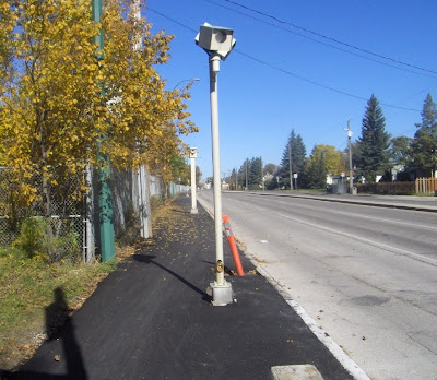
I am pleased to see that the Multi-use path along Archibald St., part of Winnipeg's new active transportation network, is coming along nicely. Especially the obstacle course portion. That's the part near Elizabeth Rd. where you get to dodge people waiting for the bus as the path turns into a bus stop platform, and then you get to swerve around posts sticking out of the path.

The best part is where the path narrows to only 2.4 m, 1/3 of which is rendered useless by red light camera posts.

It wouldn't be hard to clip a handlebar against that post, especially at night.

An acquaintance of this blog's phoned active transportation coordinator Kevin Nixon and asked him about this. Kevin had no idea that this was the case. He knew that the path got quite narrow at this spot because, apparently, the St.Boniface Golf Course refused to part with any of it's land, but he had no idea that it was impaled by red light camera posts.

One might think that this is potentially dangerous. That perhaps somebody working on the project might stop and say "wait a second ... is this right? Maybe we should check into this." Or one might suppose that Kevin Nixon himself might tour the various projects just to make sure that everything makes sense in actuality and not just on paper.

It would be easy enough to fix: they could divert some money from the "traffic calming" measures on Grosvenor that nobody wants (even cyclists) and use that cash to relocate the traffic signal posts to the back edge of the path where they would be less in the way. As for the red light camera, the thing takes less than one photograph a day. It's probably a money-loser. Why is it even there?

Anyhow, Kevin said that he would look into it. We'll see about that. I hope he doesn't, because I'm a bit of a trill-seeker, and swerving around posts on a narrow pathway adds that extra element of danger that I crave when I cycle to work.

Tuesday, 24 August 2010

Assiniboine Ave gong show

I thought I might scan and post the picture from Saturday's paper of the up-coming changes to Winnipeg's Assiniboine avenue as a public service, because it's clearer than the "easy to ready map" posted on the City's web site, which is not only in the wrong orientation and split into two halves, but the arrows on Hargrave are obscured, and not enough of the street is visible to show that it's only a two way for part of it's length. Looking at the web map you might get the impression that the whole street is now two-way.


Now, I'm not a traffic analyst, so I'm not going to comment on the wisdom of these changes until I see them in action -- although I guess I already did with the title of this post -- but I will say this: it looks like a bit of a clusterfuck.

Streets that change from one-way to two-way can be confusing for some drivers, but not only does Assiniboine change from one-way to two way, but it is at different points both one way east bound, and one-way west bound. With this arrangement, Kennedy and Carlton essentially become local-use-only, as they go nowhere except up Edmonton, while Edmonton becomes the only way out for traffic coming off of Osborne, Kennedy, Carlton and Hargrave, potentially becoming much busier.

Who knows? Maybe this is genius. Maybe once it gets implemented it will amaze and dazzle with it's safe and efficient management of cars and bicycles. Or, maybe it will just be a maze.

Monday, 16 August 2010

The camera always flashes twice

Don't mind the title of the post. I'm not at my best today.

I have no idea where Wise Up Winnipeg is getting the money for their upcoming advertising blitz, but best of luck to them. I have never been nailed running a red light, but I have been caught "speeding" a couple of times. I put speeding in quotes, because it depends on your definition of speeding: driving faster than the posted limit -- or driving an unsafe speed.

What am I talking about? Some of the cameras are set up on stretches of road with speed limits that are too low. This is not my opinion. This is fact, based on traffic studies and universal traffic standards, documented in a report that was signed by the director of public works and went before council several years ago -- January 13, 2003 to be precise -- and was promptly crapped-upon and thrown in the trash. Luckily before it was thrown in the trash they posted it on the web site and I printed off a copy, though I believe it has since been taken down. I still have my hard copy somewhere though.

What I am getting at is: if you're going to use automated cameras, it should be done within the spirit of the law, not just the letter of the law. The laws within the highway traffic act exist to make the streets safer. If you ticket people who are driving a safe speed, you do not do justice to that cause. You make people cynical and pissed off. Worse, if you actually risk increased accidents by having yellow lights artificially low, as Wise Up Winnipeg is suggesting, then you are actually working against what the laws are trying to achieve. You are compromising safety for revenue.

By ignoring recommendations by professional traffic analysts to increase speed limits, and by ignoring ITE recommendations as the WUW folks allege, the city is negligent in it's responsibility to make the roads as safe and efficient as possible, and is abusive in it's use of red light cameras. Of course, if they weren't negligent and abusive they probably wouldn't make any money.

Our goal is simple—to reduce collisions and injuries by reducing red-light running and excessive speeding. -link-
Wait ... where did I put that thing ... Oh, here it is!
So, good luck to W.U.W.. Maybe you can make it an election issue. From the comment count on the Free Press web site, it certainly seems to have some interest.

*****

Speaking of cameras ... and bike paths ... the Multi-Use Trail along Archibald St. is coming along nicely, except for the red light camera sticking right up in the middle of it. This is near the intersection with Elizabeth Rd, where the path is quite narrow because of the boundary with the St.Boniface golf course. I was wondering what they were going to do with that when they started working on the path. The answer: nothing, apparently. I guess the revenues from that camera -- a piddly 111 offences YTD -- are so important as to necessitate turning the multi-use trail into a dangerous obstacle course. Maybe they'll stick a piece of reflective tape on it or something. Ya, that oughtta do the trick.

 
/* Google Tracker Code